Yesterday the orange windsock at the hang gliding launchdeck in Fort Funston Park was blowing straight out, so right for flight. Four gliders were up when I was there with more coming into the area.
Wish I could get better transportation to and from. It’s the same problem I have when visiting San Bruno Mountain Park: have to trek a long way to get to and from these parks. It doesn’t appear that the #18, which I took back, stops anywhere along Skyline Blvd. on Lake Merced’s west side until it gets all the way up to Sloat on Skyline, behind the Zoo. The #18 ends up at the Legion of Honor at Land’s End, traveling mostly on 46th Ave.
To get to Fort Funston took the L Taraval Metro to the Zoo (end of the line) and walked along the cliffedge above Ocean Beach to Skyline Blvd., then continued on the bike lane to the park entrance. It seems close to a mile.
As you walk a little way into the park from the main Skyline trailhead, you’ll see an old wooden stairway in the distance. I call this the “John Muir” steps since it’s near that street. Counted 173 steps today, some completely sand-covered (first pic). At the top of these steps are multiple doggie waterbowls below a drinking fountain.
This has got to be the world’s doggiest park; it’s offleash. Dozens of pooches joyfully chasing each other over the rolling dunes.
Spent some time enjoying the hang gliders since I don’t see ‘em that often (second pic).
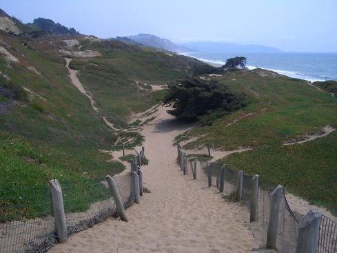
Slightly to the south from the hang gliding area dramatically descends San Francisco’s second Sand Ladder: last three fotos. (The other Sand Ladder will take you to the Presidio’s Baker Beach.) The steps turn into a sandy trail about halfway down that continues to the beach.
Decided to hike a more secluded part of the park without so many people on the trails. Back at the top, continued to the north side, following the seemingly endless wild-dunes trail as it curved round. Would like to see a few more trails down to the highway from this end of the park though. There IS, however, another trail down to the beach from this side.
A narrow “horse trail” (so advise two trailsigns) then winds through a forest high above busy Skyline Blvd. (which wide street divides Lake Merced from Fort Funston). The trail eventually took me back out to my beginning, to the foot of the John Muir stairway.
Recreational rowboats were colorful on the lake below as I headed up to Lake Merced's north edge (the south end of Lake Merced is at the San Mateo County line). This above-the-lake route is a very popular jogging trail.
Recently discovered a Nature in the City e-letter article from Feb. 10 called “Creeks to Peaks.” Passing it on:
“On Wednesday, February 1, the Capital Committee of the Recreation & Park Commission voted to move approval of the Twin Peaks Trail concept plan to the consent calendar of the full Commission meeting to be held on February 16 at 10 a.m. at City Hall in Room 416.
This is great news, not just for Twin Peaks, but because together with the Glen Canyon Trail improvement plan approved by the Commission in August 2011 these two trails will link to create the "Creeks to Peaks" Trail. Trail users will be able to hike approximately two miles between Islais Creek within Glen Canyon Park and the top of Twin Peaks while experiencing a variety of natural features along the way and access to panoramic views of the city from the top.
You can find the proposed concept plan and community meeting materials on this site”:
http://sfrecpark.org/Twin-Peaks-Trails-Project.aspx
This really gets me goin’. Glen Canyon IS a ravine of Twin Peaks after all. Want to see a pedestrian overpass across Portola, though, instead of having to cross the street to continue up.
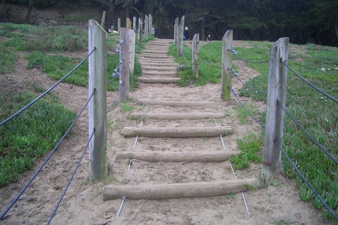
John Muir stairway into Fort Funston Park
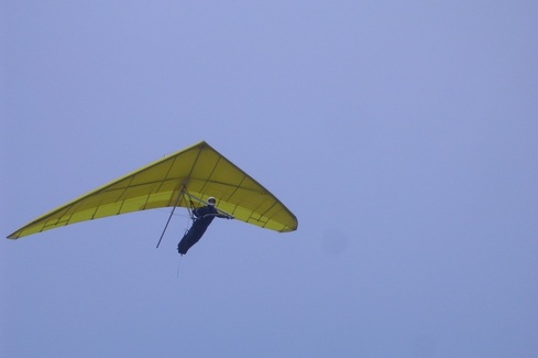
Soaring over ocean and dunes
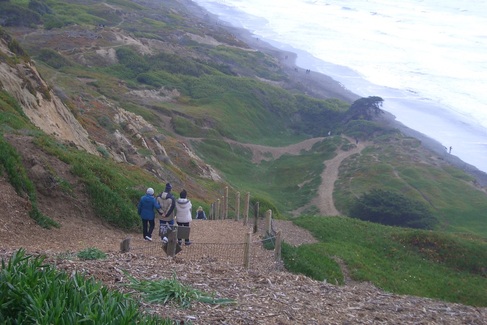
The Sand Ladder descends to Ocean Beach
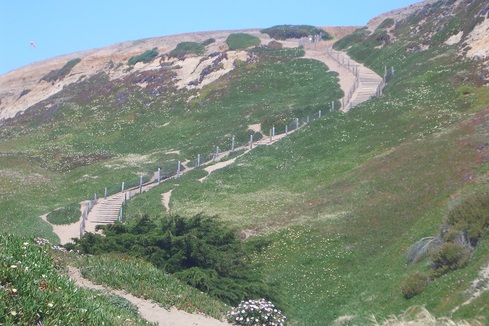
Sand Ladder Trail
Sand-covered steps turn into sandy trail partway down the Sand Ladder
 RSS Feed
