It’d been a while since I last visited Bernal's newer southside stairways (completed around 2008).
Trekked up Virginia several blocks from Mission to Elsie (first photo), then Moultrie’s 19 steps to the park. From here to a short trail off Ellsworth and a little gardenspot, with the same 15 wood steps down to Gates as before.
Then steeply uphill to the top of Gates where 34 steps climb to Bernal Heights Blvd.
Along the Blvd.’s auto barrier a few yards to the top of Prentiss, 52 steps. This one descends from the Blvd. nearly to Chapman, the foot above the Prentiss sidewalk steps (on one side, down to Powhattan).
Passed along the top of the Nevada & Chapman stairway (down to Bernal Heights Blvd. /Powhattan), a double stairway, the older steps next to the houses on the east side (second pic).
Huffed steeply to the top of Chapman, turning here onto a dirt road, the beginning of Mayflower, for a two-part stairway. From the Blvd. to unpaved Mayflower is 27 steps (third pic). A few yards away to the east, another stairway (24 steps) descends from Mayflower to the top of Rosenkranz. There's no street sign here but the top of the older Chapman & Rosenkranz stairway (down to Bernal Hts. Blvd./Powhattan) is visible from up here.
Mayflower is supposed to be a real street all the way from its dirt beginning just below the park down to Holladay, but you’d never know by looking at two blocks of it.
After the open Mayflower Garden steps (fourth photo, basically unchanged since my last visit, 13 steps), if you cross the street and look down, this is also Mayflower, Bradford to Peralta.
It used to be even more impassable. Now they’ve cleared some of the tangles down from the top and there’s a little garden with a white wood plant border. It’s steep, no steps, and when I reached the foot at a big tree stump, couldn’t see an easy way down the rest of the way.
It’s supposedly passable, according to an account I read once of someone’s exploration along the length of the street. But it also appears one would be rewarded with scratches, stepping in unseen holes, and otherwise not finding an easy way down.
So since Mayflower is not private property, I’d like to see the city (or the residents) construct a sturdy zigzag stairway on both these now-impassable hillside blocks much like the Jarboe-nearly-to-Tompkins on Bradford (Bernal’s newest stairway), or Telegraph Hill’s Vallejo steps up from Montgomery. Or a regular non-zig stairway up the middle.
Either way, make it walkable for several blocks all the way, from just below the park down to Holladay -- easy access for the fire dept. and people walking to and from the park without having to detour.
Neighbors would have plenty of room to garden on either side without all the impenetrable brush that’s there now. (I’ll volunteer for such a project if someone’ll find me a house along the route.)
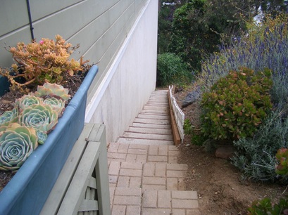
The next level down, from Peralta to Franconia, is still an impassable jungle but there are now two resident-made stairways that descend partway, one of bricks in the center and one on the north side alongside a house’s wall (fifth photo). But these don’t go all the way down either and the tangles here look rather forbidding to try to push through.
From Franconia to Holladay, the lowest block, is the older Mayflower stairway, this one perfectly walkable.
At the south end of Franconia and east end of Powhattan, the sidewalk along the chainlink fence has been cleared of weeds. Now one has a better view of the freeway below and all the trash dumped along the hillside (there’s a hole in the fence).
Didn’t do the Banks steps that climb up from Powhattan to Chapman today, nor the newest Bradford stairway.
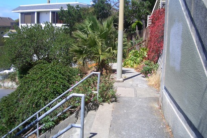
Virginia & Elsie
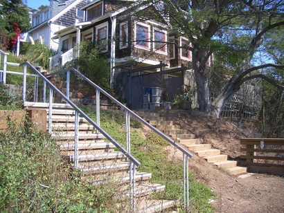
Bernal Hts. Blvd. & Powhattan up to Nevada & Chapman
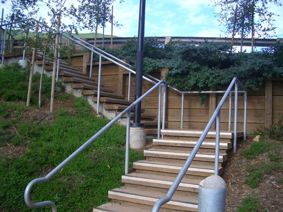
Mayflower up to Bernal Hts. Blvd.
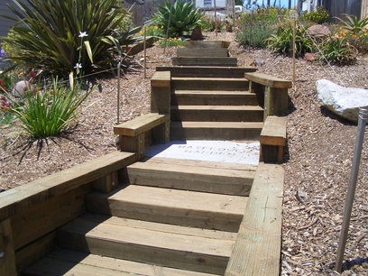
Mayflower Garden up to Carver
A resident-made stairway on Mayflower, Peralta to Franconia
 RSS Feed
